Chimborazo Quilotoa: But the Earth is round?
We had planned to spend a few days exploring the Ecuadorian highlands region, which Humboldt, 200 years back, christened "The Avenue of the Volcanoes". This is an area where the Andes are divided into two parallel ridges, including, opens to a huge valley 3.000 meters. We were interested, inter alia, because that plateau extends for hundreds and hundreds of miles through Peru, Bolivia and arriving at North Argentina and Chile. All under the cultural imprint of the Inca Empire.
We first visited the Quito old, whose architecture and urbanization have the seal of their Spanish colonial past. The churches of the Jesuits, Franciscan, Dominicans, government buildings and the homes of former strongmen of yesteryear we reminisced Latin Americans share common. The narrow streets of the old center isolate it from the chaotic traffic, thus maintaining some colonial tranquility.
In the Avenue of the Volcanoes, so named for Humboldt, the Andes are divided into two parallel ranges separated by a vast plateau
After the city tour we rented a car and head towards our true goal: Avenue of the Volcanoes. The first destination was the traditional fair Otavalo. The town comes alive when it is organized. Women wear hats and blouses with colors and designs, the knower, tell you exactly what part of the country comes each. While the original reason the show is selling regional products, many of the jobs advertised selling copied CDs and DVDs without paying royalties; a clear sign that modernity also reaches the plateau. I bought a very special chess. Parts, all hand painted, represented a battle between conquerors on horseback led by their king and set on fire Inca army led by the Inca. The small asking price the seller was so low that I was embarrassed regateárselo.
With underarm chess we start due south. We spent the night in the colonial Hacienda La Cienega, where they spent the night the famous explorer and geologist Alexander von Humboldt. A bust of the German, very young, remember whizzing. I could not resist the temptation to take a picture imitating in pose and expression.
At night we shared the table with backpackers from all over. We talked about a spectacular nearby crater, Quilotoa
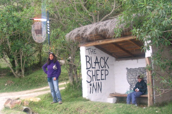
In the central part, flatter, traditionally settled valley estates of the rich Creole and Spanish. Instead, the side slopes were exploited lands by indigenous communities. We, we wanted to know the area, reserve a cabin at a popular Eco Lodge called “The Black Sheep”. Why that name in English?, will ask the reader. Several years ago an American couple settled in the area. As a means of survival created this lodge who immediately began to be highly recommended by backpackers and budget travelers guide. Nothing fancy, all with low environmental impact. The cabins share a bathroom without running water toilet! The waste end up in a pit with volcanic stones, lime and some plants that feed on them. Yes, the view from the bathroom of the two volcanoes is a must.
At night we shared the table with backpackers from all over. None spoke Castilian so the main issue was how to survive in Ecuador without speaking Spanish and Quechua! Mil hilarious anecdotes. Another of the interesting things that were discussed was the spectacle of a nearby crater.
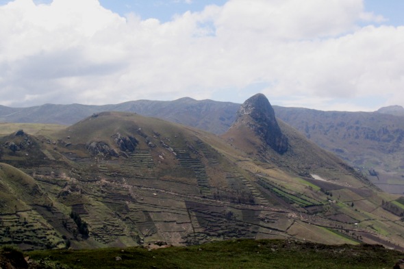
We were at the edge of a huge crater of a mile in diameter that framed, far below, a huge lagoon unforgettable color
In the morning we continue south, carrying a German globetrotter, to Quilotoa. This is called the crater we talked about last night. The road was terrible. Up and up we, but finally arrived and we got our reward. The view was amazing. We were at the edge of a huge crater of a mile in diameter that framed, far below, a huge lagoon unforgettable color. Above we noted another volcano, the Iliniza. You could choose to go down to the lake before returning to mule, but we declined because the roundtrip took hours. In the parking lot, where some Indian women selling souvenirs, German we say goodbye.
Our route took us over the south, until City Riobamba. There had fought, in the war of independence, Argentine general grenadiers José de San Martín. One of his officers, Juan Lavalle, se ganó el apodo de «El león de Riobamba» ya que su arrojo permitió ganar una batalla a los realistas. That same audacity led to his death, during the Argentine civil wars Jujuy, southern end of this long valley highlands.
In the eighteenth century the French organized two expeditions, one to the other Scandinavian Lapland to Ecuador, to ensure that the Earth was round
Our trip was coming to an end, so we return to the north passing between the two highest volcanoes in the world, the Cotopaxi and Chimborazo. It is incredible that glaciers in Ecuador but the answer is that the height compensates the latitude. These ices are almost 6.000 meters above sea. With the car I tried to approach them, but after the 4.000 made up their toll and left the Rise.
The same day we had to take the plane back we visited the most important from the standpoint of geodetic. Himself went to Ecuador, where a monument and a people living settles it. In place of elegant antique busts characters recall the famous French geodesic commission that explored the area in the mid-eighteenth century. The story is very interesting. It turns out that the French geographers discussed their knowledge of the world. What shape was the planet? Was it round the flat? With a huge bet by, whose prize was the glory of recognition, organized two expeditions. A cercana North Pole, in Scandinavian Lapland, and one to Ecuador, in the heart of the Spanish colonies. The aim of both was to measure the distance covering one degree of latitude and so would know who was right.
The thing was not simple for those sent to Ecuador. It was rumored that the real purpose of the expedition was to find the treasure of the Inca
The thing was not simple for those sent to Ecuador. Not only took them a long time to get permission from the Spanish crown, but to take their equipment to such height also cost them greatly. In Quito nobody believed in their scientific reasons. It was said that the real reason for the expedition was to find the treasure of the Inca. This distrust, coupled with their arrogant attitudes, the French did win the hatred of the locals. One of the French, The surgeon Jean Seniérgues, had no better idea to take a lover to the wife of a powerful Creole.
All went wrong, time passed and the results did not reach. In one of the many revolts of Quito, Seniergues found dead. Creole Revenge?? Team also cartoonist died of a mysterious illness. The rest of the expedition was less enthusiastic. Measurements, full of errors do not lead to anything. Finally, from Lapland came the information that the other expedition, with remarkable inaccuracy, had concluded that the earth was flattened.
In its myriad twists and turns the commission had built a small monolith marking the zero point latitude, according to your measurements
Yet the Commission left its mark. Se especula que el nombre del país tuvo su origen en que el jefe de la expedición francesa escribió tantas cartas solicitando permisos y apoyo al «Virreinato del Perú y Real Audiencia de Quito», official name of the region, he began to shorten it to "Region of Ecuador" and so the name started being grounded remaining as the country name.
In its myriad twists and turns the commission had built a small monolith marking the zero point latitude, according to your measurements. In the same place, almost 200 years later, monument rose much higher and, he grew up around a village. Currently a yellow line marks the line of Ecuador. There Tourists are taking pictures with one foot in each hemisphere. After instant sought us out original my gps to verify geographical coordinates. For some reason, I was not surprised to discover that the monument was not exactly on the Ecuador but about 300 meters it.
