Baltoro: Journey to the Center of the Earth
Lo himself a trip to the coast are obviously las olas, beaches, them cliffs; if you're a museum, them Cuadros, showcases them; if you're a forest, trees and, if you al desierto, them dunes. Then, I do introduzco by one deep crack de la tierra, planet in between masses of rock that I nearly enclose thousands of feet above me what is the object of my visit? It is clear: las Piedras abysmal, to them that you are covered common, hundidas, Compact, namely, them bowels of the Earth's crust, ahora exceptionally affordable in it this deep fissure, Cuyo random background is covered in the corners for him that he runs the water in which it is embedded on it hielo… Then, What do speaking about in this crack in the stone? Of these Piedras, of ore it, of you that hay.
Quien comes into it valle del Baltoro, open in the Mountains Karakoram, surrounded by large peaks, Needle rock massive walls, of glaciers, the best you will find to see and count are such stone, such ice. Its landscape is pure aesthetics at all scales geological. Aesthetics shall entail the walker or will learn, for being so peculiar, Progress. But someone will have to tell it geology and, her, here your experience will be much more complete than without it. Walker is the Baltoro as a character Verne, someone who has a great opportunity to enter the interior of the Earth, although, course, in this case without losing sight of the sky overhead. So around him is pure Earth, yet paradoxically profound among the highest summits of the Cordilleras.
Is the Baltoro walker as a character in Verne, someone who has a great opportunity to enter the interior of the Earth
The Baltoro is a gap between peaks of eight thousand, seven thousand to six thousand feet. In effect, across the Karakoram are 4 ochomiles and 57 seven thousand, but it is at the top of this valley where there is the second highest peak of the Earth, the K2, with its summit at 8.611 m. There are fourteen eight-thousanders in the world, ten scattered by the Himalayas the highest point on Everest (8.848 m.), but the other four ochomiles, including K2, are, Instead, grouped at the head of Baltoro, emplaced in a mountain range only 25 kilometer. Also in this line more than seven thousand sixteen focus.
Between these edges, tops, extends a mighty spurs, branched and intricate glacier basin, with his long tongue well informed axis dividuali-Zada, Baltoro glacier tongue, that comes from its start in the revolt of South glacier Gasher-brum, follows by a confluence of ice to 4.650 m. altitude in the call "Plaza de Concordia" and ends at 3.600 m. altitude, after a journey of nearly 61 km. It, as, clear that what is there, as I said before, is almost exclusively full of stones and ice tongues. And what gigantic stones and what endless ice hanging from the tops of the world!
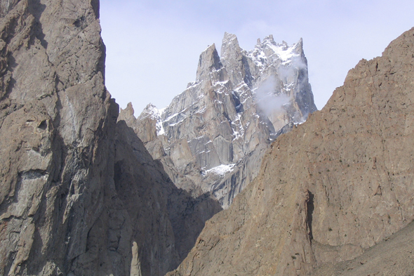
These mountains have an extraordinary beauty, so justly been called the cathedrals of the Earth
But these mountains also have an extraordinary beauty, so justly been called the cathedrals of the Earth, of huge glaciers architectures and crystal ornaments. The Italian mountaineer Maraini referred to the striking grouping of peaks called the Gasherbrum as "the family", whose members encouraged with various characters-solemn, sullen, vigorous, retracted-, linked by "high castellated ridges", that enclose an "excessive room" of ice, rock, snow and clouds in the heart of the group. A native version of Hushé Valley, expressive undoubtedly, says that Gasherbrum is equivalent to "branch" of mountains, balti but other translations give different etymologies, with references to light, the glow, to the beauty of the whiteness of the mountain. In short, a bouquet of shining mountains.
Overall, the Baltoro Valley map draws a T lying, a plant almost cruise. Their wings or upper valleys are dominated to the east by a high rock wall, that of Broad Peak and Gasherbrum. To get an idea of the dimensions must be added that such a wall scarps have slopes visible on the ice more than 3.000 m. and that, in particular, the contrast in altitude between the summit of K2 and its immediate southern glacier base is 3.600 m., elevation difference that, as is known, not reach any relief from the Iberian Peninsula to sea level.
The contrast in altitude between the summit of K2 and its immediate southern glacier base is 3.600 meters
This organization forms, so wide and bulky superlative derived from these ridges rising and resistant nature of its rocky. This is made, on one side of granitic and gneissic crystalline rocks, and compact limestone. The great wall, that forms the top of the T, thrust is due to the sector header on rocky rest Baltoro. And the opening of the great valley that splits the set so as geometric is caused by glacier action such valleys excavated over 10.000 years, but has continued and even acting on their bases. But the long axis linear path Baltoro Valley, almost perpendicular to one prominent wall of the head, due to a line of weakness, a marked fracture rectilinear, that, set to crack the rock, selectively directed the excavation of the huge glacier groove, routing for her main ice tongue.
Or, so, Three main types of roquedo: 1, gneiss and granite, giving crests and needles, from erosive opening their internal structures, as in the Trango; 2, compact and crystalline limestones, reliefs allowing resistance, despicable erect between rocks, such as whiteboards; 3, ski-ing erodible, in which the erosion is primed, more prosperous ease, paths originating valleys and in the Upper Baltoro wings and Godwin Austen.
And 1841 an earthquake caused a massive slide of the left slope in the Indus Valley, up to the start of the massif of Nanga Parbat
In sum, There are six major groups of landscapes. The two fundamental in the set are, as, the wall of high peaks and groove that runs along the main glacier tongue. The opening line of the upper valleys, the third group, is adapted to a shale-sa inner band. And the formidable masses that frame these valleys are, therefore, from west to east: 1No, torreada and geometric shapes in granite; 2No, and pyramidal forms of acute altitude in gneisses; and 3rd, concentration of large peaks in sedimentary rocks hard, them as they are resistant limestone.
Apart from these features, However it conjunto del Karakoram mountains and western Himalayas it, here almost meet, tiene una fuerte dynamics, both the mobility of the Earth's crust as the instability of slopes and them he erosive power of rivers sus. A buen ejemplo combination of this activity can sign seen in the effects of an earthquake poco fuerte mediate before he siglo XIX: in 1841 an earthquake caused a massive slide of the left slope in the Indus Valley, up to the start of the massif of Nanga Parbat, for it both in relationship with Himalaya, that it forms one large dam debris in it bottom del valle.
The dam broke suddenly while throwing the whole mass of water retained and its alluvial valley below, which flooded villages very far, drowning thousands of people
This natural dam, with huge amounts of rock blocks, gravel and sand, suddenly closed the river Indus, which in turn led to the immediate formation of a lake, whose tail upstream days almost reached Gilgit, at the foot of the Karakoram. When, somewhat later, by the sum of torrential erosion, Pressure leaks and lake waters, was exceeded resistance endpoint dam, it broke suddenly while throwing the whole mass of water retained and down the valley alluvium, which flooded villages very far, drowning thousands of people, including a battalion camped Shiks Attock, namely, about 500 miles downstream from the dam.
Dear reader, if you take these ideas in mind, Mountain understand a little. This is their nature. And maybe even notes that she thanks you with good weather and offers cloudscapes that do not appear in these scenarios. Try it.
